


WASCOTT - T 1 Voting District, Douglas County, Wisconsin
About
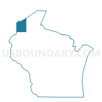
Outline

Summary
| Unique Area Identifier | 693468 |
| Name | WASCOTT - T 1 Voting District |
| County | Douglas County |
| State | Wisconsin |
| Area (square miles) | 141.17 |
| Land Area (square miles) | 131.43 |
| Water Area (square miles) | 9.73 |
| % of Land Area | 93.11 |
| % of Water Area | 6.89 |
| Latitude of the Internal Point | 46.18939380 |
| Longtitude of the Internal Point | -91.80663190 |
Maps


Graphs
Select a template below for downloading or customizing gragh for WASCOTT - T 1 Voting District, Douglas County, Wisconsin


Neighbors
Neighoring Voting District (by Name) Neighboring Voting District on the Map
- BARNES - T 1 Voting District, Bayfield County, WI
- BLAINE - T 1 Voting District, Burnett County, WI
- DAIRYLAND - T 1 Voting District, Douglas County, WI
- FROG CREEK - T 1 Voting District, Washburn County, WI
- GORDON - T 1 Voting District, Douglas County, WI
- LENROOT - T 1 Voting District, Sawyer County, WI
- MINONG - T 1 Voting District, Washburn County, WI
Top 10 Neighboring County Subdivision (by Population) Neighboring County Subdivision on the Map
- Lenroot town, Sawyer County, WI (1,279)
- Minong town, Washburn County, WI (917)
- Barnes town, Bayfield County, WI (769)
- Wascott town, Douglas County, WI (763)
- Gordon town, Douglas County, WI (636)
- Blaine town, Burnett County, WI (197)
- Dairyland town, Douglas County, WI (184)
- Frog Creek town, Washburn County, WI (130)
Top 10 Neighboring Place (by Population) Neighboring Place on the Map
Top 10 Neighboring Unified School District (by Population) Neighboring Unified School District on the Map
- Hayward Community School District, WI (13,227)
- Webster School District, WI (5,524)
- Drummond Area School District, WI (4,580)
- Northwood School District, WI (3,059)
Top 10 Neighboring State Legislative District Lower Chamber (by Population) Neighboring State Legislative District Lower Chamber on the Map
Top 10 Neighboring State Legislative District Upper Chamber (by Population) Neighboring State Legislative District Upper Chamber on the Map
Top 10 Neighboring 111th Congressional District (by Population) Neighboring 111th Congressional District on the Map
Top 10 Neighboring Census Tract (by Population) Neighboring Census Tract on the Map
- Census Tract 303, Douglas County, WI (5,066)
- Census Tract 9704, Burnett County, WI (3,780)
- Census Tract 1005, Sawyer County, WI (3,394)
- Census Tract 9501, Washburn County, WI (2,044)
- Census Tract 9606, Bayfield County, WI (2,035)